What is the jet stream? How does it form and why is it found so far from the surface? Are there different types of jet streams? This article aims to answer these questions in a simple and concise way, without however being simplistic. References will also appear at the bottom of the page for readers wishing to deepen their knowledge on the subject.
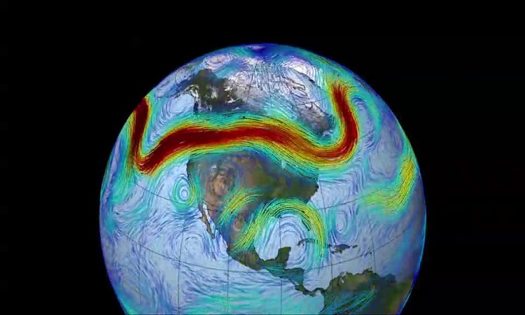
The jet stream is a tube of strong winds located around eight to fifteen kilometers above sea level, at the limit between the troposphere and the stratosphere, called the tropopause. The average speed of the air within it is around one hundred kilometers per hour, with peaks that can exceed 450 km/h. Around it, the winds decrease very quickly, which feeds areas of turbulence in clear air well known to pilots.
Regarding its dimensions, the jet stream is on average several kilometers thick for a few hundred kilometers wide and several thousand kilometers long. This geometry thus justifies the frequent use of the qualifiers “tube” or “tubular”.
Recipe for a jet stream
If we stick to benchmarks of general understanding, the existence of the jet stream can be explained in a relatively simple way. The two essential ingredients being the temperature difference between the equator and the poles and the rotation of the Earth.
- The warming of the tropics by solar radiation causes the atmosphere to swell (warm air expands) while the cooling of the polar regions causes it to collapse (cold air contracts). Therefore, above the surface, a pressure difference is created between the two geographical areas. In response, the air accelerates from high to low pressures, in other words from the tropics towards the poles.
- However, due to the rotation of the Earth, the air that initially moves towards the pole is deflected to the right in the northern hemisphere and to the left in the southern hemisphere. Arrived at about 30° latitude, the flow is curved to the point of blowing almost parallel to the circles of latitude. This deviation results in a narrow corridor of westerly winds, of maximum intensity in the upper troposphere. But why do we find it so high?
A cumulative effect
When a warm air mass is near a cold air mass, the pressure difference that appears increases with altitude. In other words, the slope of the isobaric surfaces (surfaces of equal pressure) increases with the latter and the wind therefore blows more and more strongly as one rises, as illustrated in the figure below. below.
To understand this, remember that the pressure decreases more quickly with altitude in cold air than in warm air. Thus, between two pressure values on the vertical, for example between 850 hPa and 700 hPa, the distance will be greater in warm air than in cold air. By combining the thicknesses a little stronger in the south and a little weaker in the north, we end up mathematically by having a steeper slope with altitude.
In the atmosphere, this effect is reinforced by the compressibility of the air which means that the increase in the slope of the isobars as one rises is not linear, but logarithmic. Finally, above the core of the jet is the stratosphere where the thermal contrast is reversed (the tropics become on average colder than the poles). The wind therefore becomes less and less powerful on an annual average above the tropopause.
Different jet streams
This explanation of the jet stream, however, hides a necessarily more complex reality: the existence of different types of jet streams. On Earth, a distinction is made between the subtropical jet stream and the polar jet stream. However, while the subtropical current associated with the Hadley cells follows the mechanism presented in this article relatively well, the polar jet current requires the use of slightly more elaborate concepts.
The polar jet stream comes mainly from the movement created during the rise of warm air and the descent of cold air in the depressions of temperate latitudes. Indeed, a large part of the kinetic energy resulting from the redistribution of air masses leaves the depressions at the level of the upper troposphere and feeds the rapids at the origin of this jet, which is very irregular in space and time. . There is thus a perpetual and multiple interaction between the polar jet stream and the depressions of temperate latitudes.
References:
Jet-Stream Meteorology & Jet Streams: How Do They Affect Our Weather? Elmar R. Reiter / Jet Stream: A Journey Through our Changing Climate, Tim Woolings / Atmospheric Circulation Systems: their structure and physical interpretation, E. Palmén & CW Newton / The Dynamical Relationship between Subtropical and Eddy-Driven Jets, Sukyoung Lee & Hyun -kyung Kim / Atmospheric Motions, Anders Persson / Zonal Jets: Phenomenology, Genesis, and Physics, B. Galperin & coll.